HISTORY OF Vermont
western CAPE, South Africa
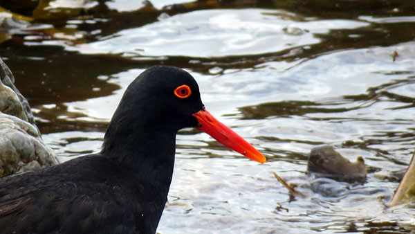
Vermont is a residential suburb on the western side of Hermanus in South Africa. The little village is said to have been built at least 100 years after Hermanus was founded in early 1800. Over the past 15 to 20 years, Vermont has undergone significant development, with approximately 22% of its land area dedicated to preserving the native coastal fynbos in greenbelts or ‘ecological corridors’. The western boundary of Vermont is a privately owned nature reserve with coastal fynbos, called Whale Coast Nature Reserve, previously called Hoek Van Die Berg.
Vermont east side borders on Onrus and on several greenbelts created in an effort to maintain the inherent tranquillity and endemic fynbos and bird life in the area. It was named by Joel Krige, and is derived from the French words ‘mont vert’ – meaning ‘green mountain’ – after the American state of the same name and probably refers to the Onrus Mountain, which serves as a backdrop to the village.
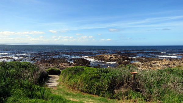
Vermont, a newer suburb than its neighbour, served mainly as a holiday village, its residents making their way here primarily during holiday seasons. However since then it has become home to many permanent residents. A beautiful coastal path stretches from Onrus along the coastline becoming what is now known as the Vermont Trail, interspersed with tidal pools and ending at the sand dunes of Brekfis (Breakfast) Bay, one of the most undisturbed beaches in the area and a perfect spot for the earliest meal of the day.
The Vermont Salt Pan is a seasonal ecologically sensitive area teeming with birdlife including magnificent flamingos which make an amazing backdrop in flight against the majestic mountains.
The entire area is surrounded by the impressive mountains of the Cape Overberg, as well as hundreds of species of spectacular fynbos that are endemic to this country. The breath-taking views combined with clean champagne air and natural beauty makes Vermont a sought-after destination. Nestled between a nature reserve on one side and the ocean on another, many properties enjoy beautiful views. It is just over an hour’s drive from Cape Town in the Overstrand Municipality.

Hermanus Early Years. READ MORE HERE
Long before European farmers and settlers set foot along Walker Bay, indigenous Khoisan (Khoikhoi and San peoples) living in kraals at Kleinriviers Kloof and Attaquas Kloof (now Hemel and Aarde Valley) grazed their cattle and sheep on the coastal lowlands in sweet limestone veld. The so-called Chainouqua tribe inhabited the Overberg area.
Piles of shellfish shells or shell middens can still be observed along the coast, further inland and among the Milkwood trees at the Salt Pan. These middens are often thousands of years old, and represent the last signs left by the Strandloper (‘beach walker’) people. They belonged to the larger communities of either the San (hunter-gatherers) or the Khoikhoi, who preferred a life of livestock herding. Strandlopers dwelled in caves and bush thickets along the shores where seafood was their staple diet. The Khoisan slowly disappeared – either forced off the land by settlers or many dying of smallpox while the remainder joined other tribes to the east or the Missions.
The recorded history of Hermanus goes back to 1724. The early 1700s brought new inhabitants when the first Cape farmers started using the pastures of the Mossel River farm, surveyed between the foothills of the Barren Mountains (Klein River Mountain).
The original farm on which Onrus (or Onrust) and later Vermont is situated is mentioned in documents as early as 1776.
Hermanus Pieters, a teacher from The Netherlands, taught at Boontjieskraal, Karwyderskraal, Afdak and Hemel-en-Aarde from 1815 onwards, as the farmers preferred their children being taught in Dutch. Pieters discovered a spring and grazing for his sheep on these shores. He camped and fished near a Milkwood forest. The spring became known to all as ‘Hermanus Pieters se Fontein’.
He died in 1837 and did not live long enough to experience the pride of the village being named after him. Many years after the founding of Hermanuspietersfontein in 1855, the local postmaster had the name shortened to Hermanus in 1902 to make his job easier. In 2005 a viewing deck was inaugurated at the spring in Marine Drive, Hermanus.
Around 1791 the grazing rights on Wageboomskloof ‘aan die Onrustberg’ (adjoining Onrus Mountain) were awarded to Matthjis Guillaume, and subsequently to Gabriel Frederick du Toit and Opperman in 1806. In 1825 Jacobus Gildenhuys took over the grazing rights of Wageboomskloof and on 15 May 1834 a perpetual quitrent was granted to him for the area below Rheezight (below the present R43 national road), ranging from the ‘Hoek van die Berg’ (end of the mountain) where the village of Hawston is now, to the border of Hermanus Pieters Fontein (now Hermanus). When Gildenhuys died in 1862 he was buried in a single grave at 17 Lukes Ave Onrus.
The farm was taken over by Beukes and Associates and was run by them until 1903. Sold by Beukes to the grandly named Onrust Seaside Township and Estate Company Ltd in 1903. A director of the company was Alexander Chiappini, which explains one street name.
Up to the end of the nineteenth century, this coastal stretch of the Overberg was a remote, thinly populated corner of the old Cape Colony. It was hardly ever mentioned in books or directories and rarely visited by anyone of significance. However, the area was being cultivated and developed and the beach at Onrust was an attraction for travellers from the Cape and further afield.
Development did not take place as the company had planned and it was liquidated in 1912. A second company bought the land, but also failed to develop sales and it was liquidated in 1928. Even then, only limited construction had taken place. A home for a Dr Viljoen had been built in 1908. In 1911 the Onrust Hotel was built, along with an inn named Ysendyk. In the same year a holiday dwelling named ‘On Trust’ was built for Mr T J Davies. He was a pharmacist from Caledon, who also recruited Alexander Grant to open a branch in Hermanus, which later became Alex Grant Pharmacy and still trades in the town.
During this period Onrus remained a single property with what we now call Sandbaai and Vermont.
The Vermont property was owned by Mr Joel Krige, one time Speaker of the first Union Parliament and named after the state of Vermont in the USA. It was as late as 1936 that Onrus became a separate village on its own, under the control of an elected ‘local area board’. Later, as the village grew, it was granted a ‘village management board’ in 1950, much later than Hermanus (1891), Poole’s Bay/Eastcliff (1920) and Mossel River/Voelklip (1935).
In the most unusual move, the ratepayers of Onrus in 1942 bought the land the village stood on. They had £370 in the bank but raised a loan of £1400 to buy the land. In 1994 Onrus became a suburb of Greater Hermanus and in 2000 it became part of the new Overstrand Local Municipality.
Vermont History
Onrust and Vermont originated as two adjacent developments during the early 20th century.
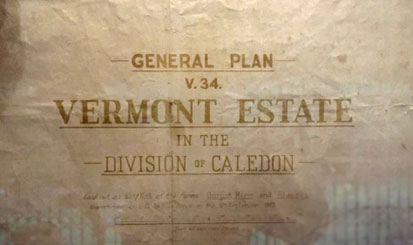
During 1913, the original Vermont Estate was laid out on Lot No. 1 of the farms Onrust River and Rheezigt and was sub-divided into 435 erven. It is assumed that the purpose of the sub-division was for the establishment of a holiday resort.
In the early years Vermont did not develop quickly as development at Hermanus and Onrusrivier was favoured. The first property transfer took place on 9 September 1913 in favour of Servaas Daniel de Kock le Roux, the property being that where the well-known artist Gregoire Boonzaaier later had his house built in 1969 on erf 572 located in Duiker Street and named Die Geelhuis.
Joel Krige was also one of the directors of the Onrust River and Seaside Township & Estate Company Ltd which was established in 1902 and dissolved in 1912. In 1925 Vermont Seaside Township Ltd was established and the scheme was laid out on land acquired from the University of Stellenbosch.
The first house was originally built in 1926 in Marine Drive on Erf 559 Vermont by Joel Krige (second Speaker of the House of Parliament), after he sold his house in Onrust to Moravian missionaries.
Joel was a member of the developing company ‘Onrust River Syndicate’ established in 1922, together with Alexander John Chiappini.
It was not until the late 1930, that Onrust was developed as a holiday destination. Vermont remained sparsely developed until the 1980s when it eventually merged with Onrust. Vermont did not develop as quickly as Hermanus and Onrusrivier and by 1933 only 43 erven had been sold, upon which eight houses had been built, and the rest of the town of Vermont was sold for £720.

A remarkably modern-day layout of Vermont can be seen in this sales plan, compiled in 1939 by H.L. Hill and later donated to the Overstrand Municipality by Mrs Susan Skog. This can now be found hanging in the Onrus offices of the municipality. It has been updated to show current street names.
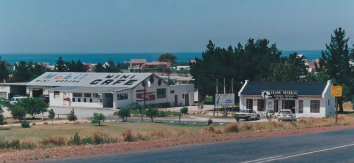
In 1967 Mr Van Wyk developed a Mini Café, Petrol station, mechanic shop, laundry and later an estate agency office and hairdresser, at the western edge of Onrus in what is now a townhouse estate named Onrus Close, off Vermont Avenue.
Jan Rabie the famous resident writer who bought his house in 1970 in Albatross Street in Vermont, at that time a town of just nine houses, but there was a shop, a post office, a butcher, a hotel and a garage nearby.
Jan later proposed that the streets of Vermont be named after local birds (Strandloper, Pikkewyn, Stormvoël, Seemeeu, Albatros, Malgas en Duiker, Fisante, Fulmar, Gannet, Malmok), animals and molluscs (Lynx, Turtle, Alikreukel, Limpet, Siffie, Armadillo) and coastal plants (Bietou, Dekriet, Kandelaar, Olievenhout) and colours (Amber, Indigo, Sienna, Saffron, Oker, Terravert, Sepia). However, the streets Glasolien, Krintang, and Milky Lane origins are unknown. Terravert was probably from the colour Terre Verte.
Helga Steyn owned this area where we now live. She then developed it and sold the plots. Our developed area was known as TERRA MISA when developed, meaning “land from heaven”.

The remnants of the two white pillars on the mountain side of the R43 above Vermont, were built by a developer of a mountainside property in the late 1980s. It would have consisted of 68 small holdings of one hectare each, but was never developed. The roads were scraped and are now overgrown.
A tidal pool was developed along the coast and a ‘badhuisie’ with cubicles was built. From the early 1970s a number of well-known South African painters, poets and writers came to live in Onrust and Vermont, including Jan Rabie, Marjorie Wallace, Uys Krige, Elsa Joubert and Cecil Higgs. More recently, actress and film producer, Katinka Heyns and writer husband Chris Barnard, acquired property in Vermont.
Bill Davis, a well-known sculptor bought property in Shearwater crescent Vermont in 1994 – his commissions include the bust of Nelson Mandela (Rhodes House in Cape Town as well several crosses at Volmoed, St Peters Anglican Church and All Saints Church (Zwe).
Gregoire Johannes Boonzaier (1909 – 2005) was a versatile and prolific South African painter. Former president Nelson Mandela visited Gregoire at his home in Vermont in 1999. The delightful Jan Rabies Pool is a tidal pool off Marine Drive and named after the author, a spot he frequently walked to with his beloved dogs Skilo, Arieb, Bekkie and Patta.
Just a short walk along the same path lies Davies Pool, right in front of the Onrus Caravan Park, constructed by Mr David Jonathan Davies. It was also locally known as “Mermaid’s Pool”.
Jan Rabie wrote in 1975 in "Moord op ons Kus" or "Murder on our Coast". READ MORE HERE
“Vermont is a small beach town with a total of 420 plots on which 50 houses stand. It borders Onrus River, and three miles further west lies Hawston, the rapidly growing town to which the bulk of the area’s coloured people have been moved. In between are high sand dunes and the last pristine strip of Cape strandveld between Cape Town and Danger Point. This entire coastline has been “developed” into an almost contiguous slew of plots. And on the approximately 12 000 plots between Hangklip and Hermanus, only 1 500 houses were built. The owner of the piece of property that would become known as Vermont Extension had previously been denied his application to develop it himself, but when the Johannesburg firm applied, it was granted leave to do so.
The people of Onrus River tried to stop Vermont. For three years they walked the narrow path of objecting only via the proper official channels. They wrote begging letters; drafted pleadings; troubled the officials; had a distinguished botanist come to provide the coast with a testimonial; they appealed to the authorities not to shred any new land until 30% of an area has already been built (Vermont is only 12% built, the entire Cape coast only 20%, while at least 50 000 plots around the Cape coast lie vacant).
In Caledon town, the Divisional Council which must look after Vermont’s interests, did not pay the least bit to the representations of Vermont’s residents, and, on the contrary, pushed the developers’ application with all its might.
Onrus / Vermont has been informed that the Johannesburg company is being granted the right to carve up a first phase of 150 plots from our beach field. With phase two, three, four already planned behind the scenes. Perhaps the emergency cry SAVE OUR SOIL is not for nothing. Perhaps our authorities hear this too.”
By 1979 there were 47 houses with only seven permanent residents.
In the 1980’s Frans Senekal Eiendomme marketed the Bester brother’s development as Vermont 4 and 5, and these erfs and fisherman cottages sold like hot cakes.
In June 1989, the then Overberg Regional Services Council appointed the consulting firm Plankonsult (Cape) to compile a structure plan for Vermont.
During 2003, The Vermont Conservation Trust (VCT) was established with the blessing of the Overstrand Municipality through the efforts of the VRA and in particular of its chairperson at the time, John Parkinson. Duncan Heard was the first VCT Chairperson and the other Trustees were John and Pam Parkinson, Barry Olivier, Councillor Tony Myles, Rita la Cock (Overstrand official), Vic Hamilton-Attwell and Tilla Esterhuizen. The VCT obtained an initial amount of R200 000 from funds originally set aside, and held by the Overstrand Municipality, for dune stabilisation by the developer of the western portion of Vermont. At that point in time however, dune stabilisation was no longer required, and the funds could be held in Trust for the rehabilitation and conservation of Vermont’s natural environment (Greenbelts). Only interest from this capital amount has been used for such projects and the capital amount has been allowed to grow to approximately R240 000 at present (Heard, 2003 & D. Heard July 2014).
In the years since 2009... READ MORE
In the years since 2009, new developments in the western part of Vermont were approved on condition that portions of the property were given off as Public Open Space. These portions of land together with older portions of land administered by Overstrand Municipality (OSM) in Vermont are in the process of being transferred into the name of OSM.
Initially water was supplied to Vermont via a servitude pipeline from Eerstekloof in the Onrusberge above the town. Taps were installed on the pipeline at intervals along Vermont Avenue to supply residents and visitors with free mountain water. This, however, became a serious problem as the water supply collapsed during the holiday season of 1967. The then Divisional Council of Caledon was responsible for Vermont and they were pressured to install a new water supply network. These water problems later contributed to the establishment of the Vermont Ratepayers Association (VRA) [now known as the Vermont Ratepayers and Environmental Association (VREA) since 2011].
During 1970 Vermont was upgraded to a ‘Local Authority Area’. The first Chairman VRA, related that on instructions from the Divisional Council, a formal VRA was formed in 1979. From about 1982 development momentum increased significantly in Vermont which now is a suburb of Hermanus within the Overstrand Municipality.
The Vermont sandy coastal plain apart from sloping towards the coast also slopes downward from the west to east. It is mostly covered by deep sand of Aeolian origin (windblown).
The south western corner of the coastal plain was part of the larger, naturally mobile dune field system, once present on the farm De Hoek van Berg (which is now called Whale Coast Nature Reserve. Over the past 50 years or more, this mobile dune field was stabilised due to invasion by alien vegetation such as Acacia cyclops (Rooikrans) and A. saligna (Port Jackson Wattle). Today the parts of the Vermont Green Belt System (VGBS) in this area have been cleared of these invasive plants but the shelter afforded by the adjacent urban areas have allowed indigenous coastal vegetation to establish and cover all the dune areas found here. VCFSA is regularly removing this alien vegetation within Vermont, in cooperation with the EMS division of Overstrand Municipality.
The southern central sandy coastal plain of the VGBS is characterised by significant dune slack areas covered with White Milkwood Tree (Sideroxylon inerme) thicket plant communities which indicate that these areas could have been vegetated for hundreds of years. Remnant wetland areas are still present in some areas of the low lying sandy coastal plain.
Dr Pat Miller stated:
“Natural systems function in equilibrium; when one part of a system is over or under-represented, another part or parts will compensate to bring the system as a whole back into balance. Nature does not apportion blame, only consequences. We are a part of natural systems, but a part that in our very short time on earth has unbalanced the equilibrium. There are, and will continue to be, consequences for our actions. We are facing the consequences.
“By our presence and actions, we have altered the balance profoundly, and as the pendulum swings back we are very likely to be knocked out by its force.
What can we do? We must do what we can.”
References
- Integrated Management Plan 2014 – 2019 Version 1 Duncan Heard Environmental Consulting
- https://whalecoastconservation.org.za/
- https://www.facebook.com/share/p/gR7P5Duf7CfaKsMt/?mibextid=U3awvj Vermont Street names
- https://www.facebook.com/groups/309242626455935/permalink/706946200018907/ Vermont Mini Café
- https://www.hermanus.co.za/info/history/estelle-spaarwater-watching-over-hermanus-heritage Joel Krige Onrust River Syndicate
- https://www.marinedrive.co.za/more-information Erf 559 Vermont
- https://www.facebook.com/VermontRatepayers/posts/pfbid028EwjBbyktkCXV9xRo8X1XKPbazs218nwaUCwTT7EvSK2856ZUeCF6UgeivZWAewgl Vermont Estate 1939 Sale Plan